Map of The Dandenong Ranges Hiking Trails
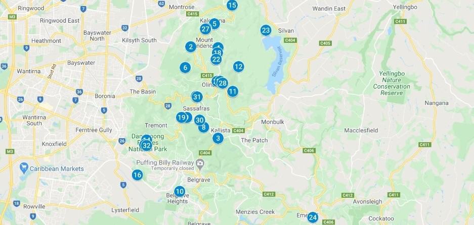
Dandenong Ranges Map – All 32 Dandenong Ranges walks on our website are embedded on the map below. Complete links to the hiking notes of the Dandenongs walks, plus directions on how to get to the start of each hike by car or public transport.
Dandenong Ranges Map
- Use the map to find the best bushwalks in the Dandenong Ranges National Park
- Download the free e-Book with walk notes and some of the best things to do in the Dandenong Ranges
Which Dandenong Ranges Walk will you do next?
The Thousand Steps hiking track (walk no. 14 on the map) is definitely the busiest, and no wonder as it is the easiest to access from Melbourne and has gained a well-deserved reputation as being an ideal challenge and fitness trail that includes amazing scenery and the occasional Lyrebird too.
Further into the Dandenong Ranges National Park, numerous trails await discovery. How about getting the train to Belgrave and walking from Belgrave to Sassafras? This stunning trail passes through the Alfred Nicholas Gardens and the Sherbrooke Forest.
- Discover the beautiful gardens in the Dandenongs with directions included.
- The Dandenong Ranges also offers many attractions and activities.
- Pram Friendly Walks | Wheel Chair accessible walks | Dog-friendly walks (all on-lead apart from the old Olinda Golf Course)
- Picnic Grounds & BBQ’s | Viewpoints
- There is a good playground at Olinda with wonderful views as well as a fabulous off-lead dog walking area.